| |
|

West coast
Between Johnson Pt and Five Islands
It’s shallow (5-6m) for 1-5M or so off the shore on this stretch of coast and you should watch out carefully for the many shoals, which are hard to see. Making this passage requires exact navigation, especially if you draw >2m. Once you have given Johnson I and little Pelican I a wide berth, head for the westmost islet of Five Islands on 345°. This should keep you in at least 4-6m.
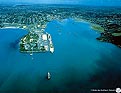
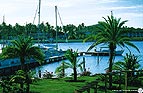
Jolly Harbour
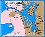 This is a huge lakeside complex, enclosing a very large, excellently protected, all-weather This is a huge lakeside complex, enclosing a very large, excellently protected, all-weather
marina. The 200 hectare basin has been dredged out of the old Salt Pond. A buoyed channel (in theory dredged to 4m) makes for easy access from the W by closing the first, easily visible, lit starboard mark. You can anchor out, preferably S of the channel. Inside, artificial islands dotted with multicoloured buildings have created a canal labyrinth in which every plot has its own pontoon. Towards the SE end of the lagoon, in depths of 4m, you’ll find the marina with its 150 berths, fuel dock and boatyard.
Note Anchoring in Jolly Harbour is prohibited
Ashore Customs and immigration are on the E coast, allowing you to clear in and out. Mooring is available on one of the two pontoons in front of the administrative buildings. The port office (VHF 16) is on the upper floor of the small shopping centre in which there are several shops and restaurants including a post office. There’s a dive centre operating around the nearby reefs. For services you’ll find the marina has both a boatyard with a good range of services and several independent specialists, including Budget Marine’s extensive chandlery. Visiting yachts will find most necessary provisions for maintenance and breakdowns. You can also complete entry formalities here. These facilities, combined with the exceptionally warm welcome of the manager and the fact that the marina is very well maintained, are making it an increasingly popular first port of call.
Around the large basin the lakeside real estate development has a swimming pool, tennis courts and an 18 hole golf course. For nightlife there’s a big white rotunda-shaped building with colonnades which houses some shops, a very chic bar with a huge casino, and an upstairs restaurant with panoramic views over the marina.
Saint John’s Harbour
St John’s is a commercial harbour and the capital of Antigua and until recently wasn’t much frequented by yachts. However, thanks to the development of Redcliffe Quay for yachts, it’s now easier to visit St John’s and its historic quarter, as well as provisioning at the many shops.
A wide, dredged and buoyed channel makes entry easy. You can anchor S of Redcliffe Quay, but there’s an absolute prohibition against anchoring in the channel or within the manoeuvring basin where the big cruise ships come in to moor at Heritage Quay Pier. The same goes for the new Nevis Street Pier further S of Redcliffe Quay. If you’re in this part of the harbour at the same time as one of these large vessels, it’s best to notify the harbour authorities on VHF 16 (Deep Water Harbour) so they know you’re there and where you’re heading. You can moor on the Redcliffe Quay visitors’ pontoon for a long or short stay, with permission from the dockmaster of Key Properties Ltd. (formerly the Antigua Pier Group Company) whose office can be found in Back Street, Redcliffe Quay (VHF 16). There’s water but no fuel dock.
Ashore There are two customs and immigration offices, principally for cruise ships but also for use by pleasure craft. The main one is close to the main commercial dock in the N of the harbour, and it’s here that you’ll also find the harbour authorities if you want to clear. The other customs and immigration office, near Hermitage Quay, is often closed.
Fringing Redcliffe Quay the small, colourful houses have a village air, with their small squares and narrow alleys within which you’ll find several small shops, bars and restaurants. Around here, the centre of St John’s, you’ll find the liveliest and the most interesting part of town, worth a stop for a visit to the old quarter and its monuments. Several restaurants offer local specialties at good prices. For provisioning there’s a good local market (especially on Friday and Saturday) as well as lots of shops and supermarkets. As far as yachting services go, they’re limited to a few mechanics and outboard specialists.
For more details on other moorings and shelters
Morris Bay
Five Islands Harbour
Deep Bay
Dickenson Bay

East coast
Nonsuch Bay
A large bay open to the sea but entirely protected by a large barrier reef and by Green Island. Along with North Sound it is the best anchoring area in Antigua. It can be reached either from N whether from Long Island or Barbuda, or from S coming from English Harbour. (The latter is the best way round to take things.) A conspicuous sea mark to the north of Half Moon Bay on the top of Friads Head is a white house with what looks like a small bell tower. Hold well E of York Island before altering to 320° using the right hand end of Conk Pt as a leading mark, leaving to port Neck O’ Land Island with its nearby wreck. The coast here is dominated by the exclusive Mill Reef Yacht Club development with its many fine houses. Be sure to give the large offlying coral banks S of Green Island a clear berth.
Red Cliff Marina
- St John Harbour
|
|
|
|
Green Island
On the S coast of Green Island there are anchorages in the two small inlets except when there is a well-developed SE wind. Tenpound Bay, the further E, is the narrowest and most exposed in a SE wind. On the beach there are picnicking sites built for and reserved for Mill Reef Yacht Club, which leases Green Island. Rickett Bay (Rickett Harbour) isn’t much bigger but is better protected.
The creeks can’t hold more than two or three boats given the coral that makes them very tight.

Fore more details on other moorings of North and East coasts,
Long Island
North Sound
Ayres Creek
Clover Leaf Bay
Willoughby Bay
Mamora Bay
Indian Creek
Redonda
North coast
Boon Channel to Prickly Pear Island
Coming from the SW, in order to find the anchorages off Long Island on Antigua’s NE shore, you should use Boon Channel between the offshore reefs and Antigua. From off the Sisters, staying about 0·5M offshore, hold on 065° past Weatherills Pt until NW of Boon Pt when Prickly Pear should bear about 095°. Alter to that course using the S point of the islet as a mark and staying well clear of the shoals around Boon Point.
Note To avoid getting snared by the huge complex of reefs WNW of Prickly Pear Island don’t stray N of this route.
The passage between Prickly Pear Island and the coast of Antigua needs to be eyeballed favouring the Prickly Pear Island side.
North Sound
North Sound is a large open expanse of water protected by Long Island in the N and a large barrier reef in the E. There are lots of anchorages, though navigating in North Sound has to take account of the many coral outcrops and banks. The loveliest and best protected anchorages are in the lee of Great Bird Island and the necklace of islands running off to the S of it.
BARBUDA
Coast and anchorages
Approaches
The island is about 25M N of Antigua,
off the usual route towards St Martin
and the Virgin Islands. As a result it isn’t
often visited. You must plan your arrival
to be in daylight and in good visibility.
The island is low and hard to spot from
seaward. It is surrounded by reef and
shoals, particularly the Codrington
Shoals that push out a long way from the
S coast. These shoals (3–4m) sometimes
break in a heavy swell. The best possible
approach is from the SW, thereby
avoiding the reefs and shoals of Palaster
Reef. In the N you should spot Palmetto
Pt and the ruins of the Martello tower a
bit further E. Make your approach by
heading towards the beach between
Spanish Well Point and Cocoa Point,
using the complex of hotel buildings as a
lead.
South Coast
Cocoa Point
The N part of the bay is full of coral
outcrops, so anchor towards the S
keeping clear of the shoals around Cocoa
Pt itself. Don’t anchor too close to the
beach of the Cocoa Point Lodge, it is
reserved for the water sports of the very
‘select’ clientele and doesn’t welcome
visitors. Further N, there are two further,
high end and equally private hotel
complexes but these are often closed.
Gravenor Bay and Spanish Point
In good visibility and with a careful
lookout, give the reefs around the S and
W of Cocoa Pt a very good berth to get
to Gravenor Bay. Several indentations
split up the masses of coral which
otherwise block access to the coast, and
they make quite well-protected natural
havens except when there’s a SE swell.
The most isolated of these spots is under
the lee of Spanish Pt to the S of the ruins
of an old fort, protected from the
Atlantic swell by the point and the reefs
off it.
Note The approaches to all these
anchorages must be made by eyeball in
good visibility with a sharp lookout for
the many bommies.
If the weather allows it, you’ll be able
to stay long enough to explore the
marvellous underwater world of Palaster
Reef. The whole area is now classifed as
a Nature Park.
West coast
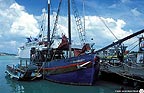
Barbuda (Boat) Harbour
This small and precarious haven, close E
of the Martello tower, an old defensive
work, serves small coasters and barges.
You can identify it by the large sandhills
on the shore and there are usually two
starboard hand buoys (red here) showing
the channel through the reefs on 030°.
Anchor in depths of 3–4m near the
entrance (but keep clear of the area
where barges and local ferries manoeuvre
to go in), then go into the inner basin
(depths 2–1m) by tender. You can get a
taxi to Codrington for shopping, and
clearance facilities if you need them.
Leave someone on board just in case the
boat needs to be moved.
Palmetto Point/Low Bay
On the S side of Palmetto Pt you’ll see,
behind the superb beach, a luxury resort
catering for a very select clientele. Once
around the long sand spit off Palmetto Pt
you’ll see the endless beach of Low Bay:
more than 10km of almost deserted
golden sand.
Note For boats drawing much water, the
shallowest water with only 2·5–3m lies
off the NW of Palmetto Pt. A thin
isthmus of sand separates the sea from
the lagoon and at the narrowest point
(see plan) you can without much
difficulty lift a light tender across into the
lagoon to get to Codrington. The middle
and the N of the bay are full of isolated
reef patches. You can get round the first,
Tuson Rock, by passing between it and
the shore in order to anchor a bit further
N, close to a resort, beneath a topknot of
palms. The anchorage is often rolly, with
a strong backwash on all its beaches
which makes it difficult to land a tender,
but this vast expanse of sand that seems
almost awash is still a rare experience,
even in the Antilles.
|
|
|